


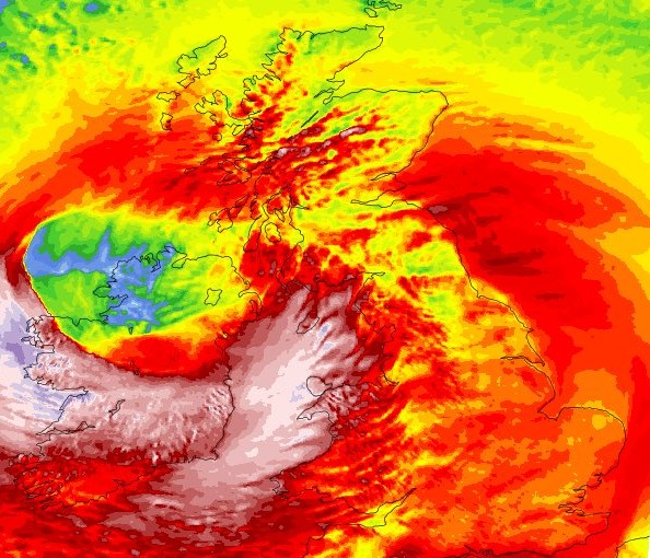
A status red warning for wind has been issued for four counties on Friday as Storm Éowyn makes its way towards Ireland.
Met Éireann is warning of a destructive gusts in excess of 130 kilometers per hour in counties Clare, Cork, Kerry and Limerick, which will lead to "extremely dangerous travelling conditions, danger to life, wave overtopping, and coastal flooding in low lying and exposed areas.
The red level alert will be in place from 3am to 10am on Friday.
A Status Orange wind warning has been issued for the rest of the country for Friday.
Met Éireann is warning of damaging and destructive winds with gusts of up to 130 kilometres per hour.
The Orange alert comes into effect at 2am on Friday until 5pm, with the potential for fallen trees, damage to power lines and power outages, structural damage and very difficult travelling conditions.
An Orange Wind Warning has been issued for Ireland, due to Storm Éowyn, beginning 02:00 Friday 24th, valid until 17:00 Friday 24th.
Please check the details below. https://t.co/XIjOm8VbJ1#stormÉowyn pic.twitter.com/MKA99rqqkQ— Met Éireann (@MetEireann) January 22, 2025
Alan O'Reilly from Carlow Weather, says the storm could be as bad as Storm Ophelia in October 2017.
"This looks like the most significant storm I've seen on weather forecasting models since probably Ophelia.
"I'm not saying it'll be as bad as Ophelia for some areas, but it could be. There is a possibility that it will be close to that, where the strongest of the winds come into the southwest or the west.
"Obviously as this storm hasn't even developed fully yet, tracking it and the exact track will change. So I'd imagine Met Éireann will be updating and possibly upgrading".
Met Éireann's Deputy Head of Forecasting, Liz Coleman, is warning of destructive and dangerous conditions on Friday into Saturday.
“Storm Éowyn will bring wet and very windy conditions on Friday, especially in the west and northwest. The very strong southwest winds with damaging gusts will start to be felt late on Thursday and will cause dangerous travelling conditions on Friday, with the likelihood of trees down and potentially power outages.
"Wave overtopping is also expected at high tide. There could be localised flooding further into Saturday associated to the heavy rain and to the snow melt.
"Western and northwestern counties are likely to see status orange wind warnings as a minimum, but we are monitoring the situation closely and will issue warnings as Met Éireann’s high resolution model, which provides information two days ahead, comes into play".
Ahead of the Orange warning, a weather advisory for the entire country is in effect immediately until midnight on Friday night.
Very strong to gale force winds are expected across the country with the potential for damaging gusts and disruption in places.
High seas and spells of heavy rain are expected also, with some falls of sleet and snow are also expected too, especially across counties in the west and northwest.
Forecasters say they're "continuously monitoring the evolving situation and weather warnings will be issued as confidence in the forecast track/intensity of the Low-Pressure system improves".


